
Notice detail below


Lines in this tree records hundreds of years of history

Petrified tree
The bible speaks of four rivers that flowed from Eden, one of which has been a mystery because it no longer exists. The Pishon River dried up some time between 3500 and 4500 B.C. and only recently we have found clues as to its existence. Satellite images of the Saudi Arabian desert north of Riyadh show an ancient river bed, partially filled with sand, working its way toward Kuwait. Pebbles in the riverbed are consistent with the granite and basalt found 650 miles to the southwest in the Hijaz Mountains. The bible claims that there was gold in the area of the Pishon River. Rediscovered in 1932 by American engineer Karl Twitchell the Mahd edh-Dhahab (Cradle of Gold) is one of the richest gold mines in Saudi Arabia. There has been found in the area remains of ancient mining efforts. Core samples of dried lake beds show how the weather in the Arabian desert was once quite different than it is today. The pollen count indicates a much wetter climate during the Chalcolithic period (4500-3500 B.C.). There was once forests where there is now nothing but rocks and sand. When we read the story of Noah building an ark we often think of him doing it in a desert with his neighbors rolling their eyes at his foolishness, when in fact there was likely plenty of trees available for the huge project.
Palouse Falls
the product of the Missoula flood sweeping through
the scabland of eastern Washington
In eastern Washington there are signs of what is called the Missoula Flood that shaped the landscape during the Ice Age (15-13,000 years ago). Large fields of ice moved down into what is now northern Washington and Montana and dammed up a large area around modern Missoula, Montana. At various times the dam would break sending mountains of water and debris flooding into the Columbia basin all the way to Oregon. Around Missoula can be seen lines in the mountains that were formed by the wave action of this huge lake just as we can see in man-made reservoirs as they ebb and flow with the annual rain fall. These lines give us a clue as to how many times the lake was flushed and how many years between it remained stable. Down stream of this lake are the signs of erratic drop stones, some were carried by glaciers while others were pushed along by the swift current during each massive flood. We can find rocks hundreds of miles from where they were once carved out of a mountain.
This large piece of granite is totally foreign to the local basalt here in south eastern Washington. There is nothing like it for well over a hundred miles to the north. It was left high and dry by a raft of ice.

The sedimentary rocks formed by glaciers however is different than that formed by oceans that are full of life. Ice Age silt produces few fossils whereas rocks like limestone are often loaded with signs of life.


Notice the weathered lines in this erratic bolder lying on a bed
of sharply broken stones. The worn rounded surface suggests
it had been at some other location for hundreds of years and
eventually it was carried here by glacier ice which
melted leaving it resting on these sharp bits of basalt which
are a totally different type of stone.
it had been at some other location for hundreds of years and
eventually it was carried here by glacier ice which
melted leaving it resting on these sharp bits of basalt which
are a totally different type of stone.

Ancient layers of lava flows now exposed by the floods that
rushed through the Wallula Gap in southeast Washington.
Rock that has been exposed to the sun's radiation gets a surface tan much like we get on our skin. Break the stone open and you can see the natural color of the minerals. Tests can be made that can give a pretty accurate date of how long the stone has been exposed to the sun. Stones that were dropped by glacier ice or flood waters can be dated as to when they found their resting place in the sun, thus giving us a time line as to the floods and glacier activity.
For a thousand years in Thy sight are like yesterday
when it passes by, or as a watch in the night. (Psm. 90:3)

Wallula Gap is where the water escaped the Columbia Basin
after each of the Ice Age floods.
 Like the lines on the shore of any reservoir the horizonal lines on the hills above Missoula show the erosion from various periods when a huge lake would fill this area being held back by glaciers.

 A mined pit near Finley, Washington exposing various layers of lava flows. Between the layers are an occasional layer of light colored ash from explosions of Cascade Range volcanoes which are up wind and to the west. Mount Mazama exploded 7,700 years ago leaving us Crater Lake in Oregon and a white ashen historical marker all over eastern Washington and Oregon.
 Each of these volcanoes of Oregon and Washington tell us a history by the lava and plumes of ash that they have emitted over the centuries. The prevailing wind comes from the ocean therefore the ash is usually deposited inland to the east.

.

Dale Brown standing in the desert next to petrified trees that grew thousands of years ago. Since that time mountains have pushed up in what is the Cascade Range that hold back the moist air from the Pacific coast. No forests of this kind have grown in this area for thousands of years.


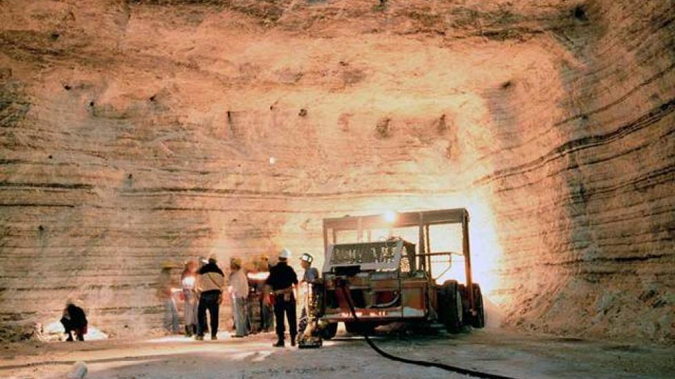
Cargill Salt Mine 1,800 ft. below Lake Erie
Layer upon layer salt is found under Lake Erie which was deposited by a sea or ocean thousands of years ago. These layers can be counted which speaks of various time periods of ebb and flow of climate change over the centuries.
https://dale-apologetica.blogspot.com/2018/07/rock-of-ages.html?showComment=1535203814061#c6692121311261237339
No comments:
Post a Comment